Dangerous Northeast Snowstorm Threatens Post-Christmas Travel
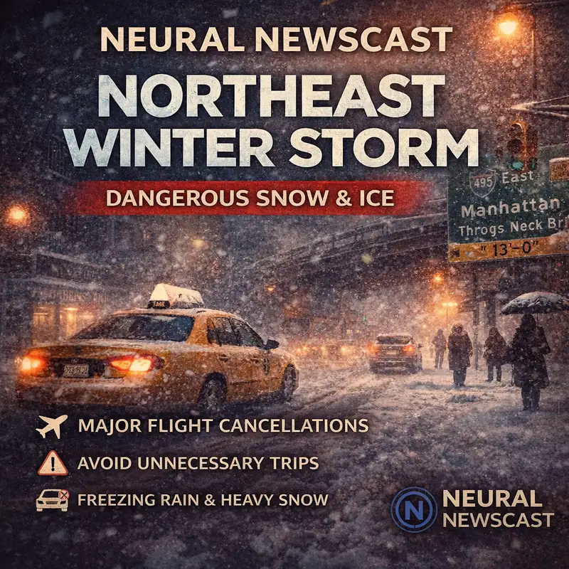
You are listening to Neural Newscast. I'm Oliver Grant. A major winter storm is pushing into the Northeast, and it's already messing with post-Christmas travel. We're looking at heavy snow around New York City, and then dangerous icing in other parts of the region. I'm Julian Mercer. And yeah, this is one of those systems where the details really matter, because it can flip fast from snow to sleet to freezing rain. And the travel risk basically depends on which side of the storm you're on. It started out in the Midwest, and parts of Wisconsin and Michigan are already seeing ice on the roads. And that early icing is kind of the warning sign for what spreads east. Less traction, longer braking, and a much higher chance of crashes, even if you're not going very fast. As it moves into Pennsylvania, freezing rain is expected to cover the entire state through the day Friday. which turns a normal drive into a high-consequence decision. There's an ice storm warning in place for nearly one million people in western Pennsylvania. Now, on the colder north side of the storm, the main hazard shifts to heavy snow. ABC News reports significant snowfall is expected across parts of New York, eastern Pennsylvania, New Jersey, Connecticut, western Massachusetts, and Rhode Island. Timing matters here, especially for commuters and anyone traveling. Snow starts in western New York Friday morning, and it's expected to reach New York City by around 5 p.m. And when those heavier bands move through, visibility can drop fast, like you go from slow to unsafe in a hurry. Overnight may be the toughest stretch because the snow keeps going into early Saturday. In New York City, it's expected to taper off around 9 a.m., which basically puts the worst of it right in that Friday night travel window. And the forecast totals show why agencies are urging caution. New York City is forecast for about seven inches, which could be the most in nearly four years. Upstate New York may see six to nine inches with as much as ten possible in the Hudson Valley. Northern New Jersey is projected at five to eight, and Hartford, Connecticut could see around four. Farther south and west, it's the mix that's the problem. Philadelphia could see one to three inches of sleet and snow, plus a glaze of ice, which is often worse than deeper snow for driving. And Baltimore may deal with icy roads, too. Air travel is taking a hit as well. More than 1,300 flights have been canceled so far Friday, with New York City's three airports and Detroit Metro among the hardest hit. If you're flying, check your airline status before you leave for the airport, and plan for delays that kind of cascade as planes and crews get repositioned. Officials are in readiness mode. New Jersey is under a state of emergency, and New York Governor Kathy Hochul told ABC Station W.A.B. that snowplows and utility crews are on standby. That helps, sure, but it doesn't erase the risk when roads are icing over or visibility is dropping. One last practical note. If you've got flexibility, honestly, the safest call may be to delay. If you have to drive, slow down, leave more following distance, and assume bridges and overpasses ice first. And in snow, give plows space and don't pass on the right. And for tonight, take the forecast seriously. Storms like this punish routine. A normal trip can turn into a long wait, a reroute, or a night somewhere you did not expect to be. If you can stay home, that can be the most effective prep. That's the latest on the Northeast Winter Storm and what it's doing to roads and flights. I'm Oliver Grant. I'm Julian Mercer. Thanks for listening to Neural Newscast. If this helped, share it with someone traveling and check back for the next update. Neural Newscast is AI-assisted, human-reviewed. View our AI transparency policy at neuralnewscast.com.
Creators and Guests