Christmas Travel Whiplash: Mountain Blizzards in the West, Winter Heatwave for Much of the US
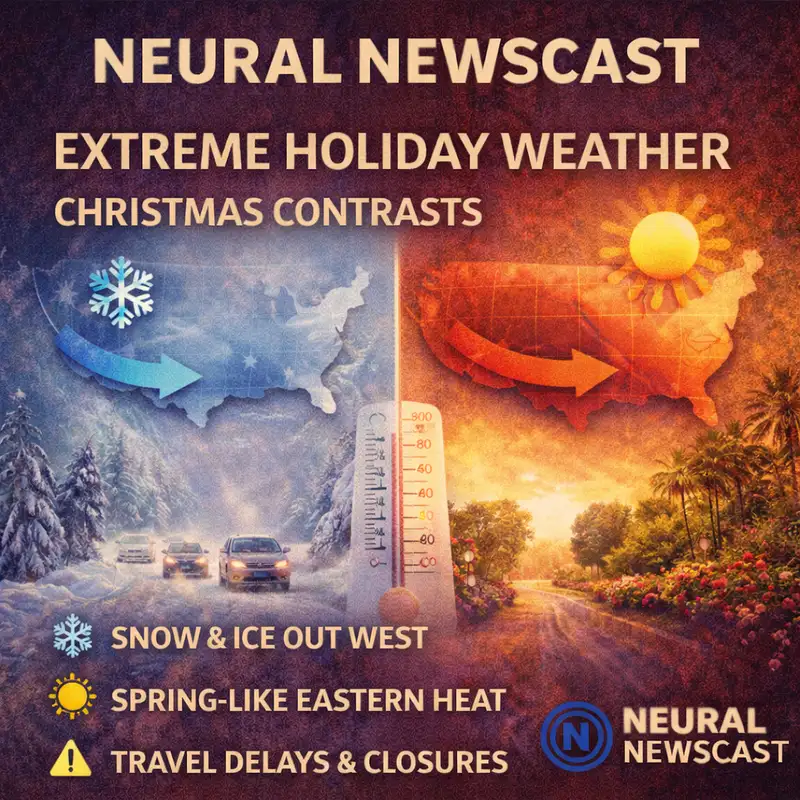
You are listening to Neural Newscast. I'm Nathaniel Cross. The big holiday travel story is kind of weather whiplash, blizzard conditions in the western mountains, and a rare winter heat wave across a lot of the rest of the country. I'm Cassidy Rhodes. If you're traveling for Christmas, yeah, this is one of those weeks where the same forecast can mean snow tires and road closures in one region, and, you know, short sleeves in another. Here's the setup. It's a split-flow pattern. In In plain terms, the jet stream is basically dividing the country into two very different lanes, with Pacific storms hammering the west, while a strong ridge of high pressure pulls warm air into the central and eastern U. On the storm side, we've got multiple moisture-heavy systems, including atmospheric river conditions, lining up for the Cascades, the Sierra Nevada, and the Rockies. In the highest impact zones, snow totals are projected in that 2-4 foot range through Christmas. And the travel risk really concentrates on mountain passes and major corridors. In California, Donner Pass on Interstate 80 is one of the flashpoints, with forecasts calling out conditions that can go from tough to basically impossible fast, with whiteouts and heavy accumulation. Up in the Cascades, routes like I-90 and us too can get hit with heavy wet snow plus strong winds, which is a pretty rough combo for visibility and traction. And even when the roads stay open, chain controls and spinouts can slow everything way down. The Northern Rockies are in play too. Montana, Wyoming, and Idaho are looking at steady accumulation and blowing snow, with gusts around 40 miles per hour in more open areas. Interstates like I-15 and I-90 could see icy patches and sudden drops in visibility. Utah and Colorado are getting those classic white Christmas visuals in the high country. The Wasatch, including spots like Park City and Alta, is forecast to pick up meaningful snowfall by Christmas Eve, and ski areas in the Colorado Rockies benefit too, even if cities end up with more moderate totals. Meanwhile, the other side of the split is the heat wave story. A big stretch of the plains, the Midwest, and parts of the South are forecast to run well above normal, with some cities in the 50s and 60s, and pockets farther south pushing into the 70s, even the low 80s. And that warmth has ripple effects. It can erase snow cover, turn some precipitation into rain, and make it a snow-free Christmas for a huge share of the country. It sounds easier for travel, sure, but conditions can flip quickly right at the edges where warm air runs into cold air. Timing really matters here. The most significant disruptions are expected through Christmas Day, especially across western mountain regions. For travelers, it's less about one single storm and more about repeated rounds that keep roads hazardous and leave very little recovery time. So what do you do if you're heading out? First, build extra time into your plan. Leaving earlier can be the difference between driving in daylight versus driving in a whiteout. Second, watch past conditions, not just city forecasts. Third, have a backup route, because one closure can cascade into hours of delay. For drivers, think the basics that prevent expensive mistakes. Full fuel, a charged phone, a winter kit, and tires that actually make sense for mountain travel. And if your route crosses the Sierra, the Cascades, or the Rockies, assume chain requirements are possible and check the rules before you hit the checkpoint. And if you're flying, keep an eye on hubs connected to mountain weather. Even if your departure city is warm, planes and crews get displaced by snow and wind, and delays spread. So yeah, a quick check of airline alerts can save you a lot of waiting at the gate. Bottom line, it's a split America forecast. The West gets high-impact winter, the Central and Eastern states get spring-like warmth, and the biggest travel risk is in and around mountain passes where conditions can change fast. That's the holiday travel outlook. Stay flexible, monitor local advisories, and plan for the route you're taking, not the weather you wish you had. If this helped, share the episode with someone traveling this week and follow Neural Newscast for more updates. Neural Newscast is A-assisted, human-reviewed. View our AI transparency policy at neuralnewscast.com.
Creators and Guests